• Welcome to AppraisersForum.com, the premier online  community for the discussion of real estate appraisal. Register a free account to be able to post and unlock additional forums and features.

Commercial Mapping Software

Status
Not open for further replies.
I second Google Earth Pro.

Set up a folder in your 'My Places' and then create placemarks within that folder, that way you can save the folder as .kmz file to your workfile if you need to revise/edit.

I would also suggest adding the mgmaps.kml layer to your 'My Places' which allows you to overlay several different map views, such as Google Maps rather than the native satellite view from Google Earth

Go to this link http://www.mgmaps.com/kml/ and download the maps.kml file, which is free. That will allow you to turn on different map layers.

Any other tips with GE Pro? I downloaded the overlay, looks better than what I had. I learned of a shortcut as well, Ctrl-Shift up or down to zoom in or out fast.
My method has been to add a placemark, delete the name, change icon to an S, 1, 2, 3, or 4, then change the size to 2.0 for the subject and 1.8 for the comps. That is what appears to look the best.
 
I used Wordperfect until 2003 when I was simply forced by the tide of Word users to switch. You must have been in the business for sometime. In the late 1980's it was the only software used. I have been an advocate for Google Earth Pro on the forum for years (even when it was a paid for service in 2008). I also use Delorme. Actually Delorme is not a self evident software and changed substantially from 2005 to 2016. In other words if you used an older version it may take time to understand the newer. After you understand how to make maps in your desired format it works fairly well. One thing I can tell you for certain, the Word format is a 100 times more stable than Wordperfect and much easier to work other programs into. If you ever bit the bullet (and we all get why it is a bit*h) it is well worth it. This is coming from a user of both. I also use to use Lotus 123 and swore never to use Excel but the truth is Excel is a better program, sad to say it is the same with Word. Once you jump the hoop you will wonder why you did not do it sooner.
 
Wish Google Earth Pro would bring back parcel lines.
 
That is what I use & I am a WP guy. You can label them, and i prefer B & W maps so using Adobe Acrobat 10 I print to pdf and change the map output to BW in Acrobat in printer dialogue. Then I use the snapshot tool in Acrobat to cut. Will paste then edit box to center and size the map.

Are you using Corel Wordperfect? What version?
 
Any other tips with GE Pro?

By far the most useful tool in addition to many of the add-ins and map layers is Google Earth's historical imagery tool.

It basically shows you the path of development over time, showing changing highest and best uses and the pace of change. You can see whole subdivisions and shopping centers spring up. Very useful for certain areas.


Sorry in advance for the remainder of a link-heavy post

Here are some other useful add-ons I have used in the past- I would suggest saving most of these to your 'My Places' by right-clicking on the links which are in your 'Temporary Places' or you can save them when quitting the application

http://www.gelib.com/maps/_NL/usgs-topographic-maps.kml - USGS Topographic Maps, (Click the download with Google Earth link in the bottom center of the page

FEMA Flood Maps - https://hazards.FEMA.gov/femaportal/wps/portal/NFHLWMSkmzdownload - This has two sections National Flood Hazard Layer, (NFHL) which is very detailed or Stay Dry which has basic info

https://www.fws.gov/wetlands/data/google-earth.html - Fish and Wildlife National Wetlands Inventory - shows FWS mapped wetlands

http://www.gelib.com/soilweb.htm - SoilWeb - NRCS soil mapping for ~95% of US Counties

http://www.metzgerwillard.us/plss/plss.kmlhttp://www.metzgerwillard.us/plss/plss.kml - Public Land Survey System - helpful for people working with Township, Range, Sections (More info at http://www.metzgerwillard.us/plss/plss.html
(There is also a paid service($50/yr or $5/month) called Earthpoint based in the Pacific Northwest but with national coverage that adds several other features including the ability to upload an Excel file to Google Earth with icons in place which might be able to streamline your maps even further Nacho

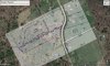
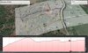
In the absence of Google Maps not showing the parcel lines, I would suggest learning how to overlay images onto the Google Earth Globe. I've attached an image from an old appraisal where I overlaid the subject's tax map onto Google Earth, then set the transparency of that layer to show most of the underlying satellite imagery.

Bear in mind it's not ortho-corrected but it's very close and can help convey a lot to the reader/intended user of the appraisal.

I also included the same image but shown on a tilted bias to convey the topography and elevation profile.

I looked at a couple tutorials, (http://www.gearthblog.com/basics) to get started but use it for a bit and you'll get the hang of it quickly.

'Free Geography Tools' and 'Google Earth Library' are excellent blogs to deep-dive in.
 

Attachments

  • Sample GE.jpg
    Sample GE.jpg
    277.7 KB · Views: 16
  • Sample GE 2.jpg
    Sample GE 2.jpg
    270.8 KB · Views: 15
Last edited:
This is the bomb diggity! Thanks for the links and tips. I wish I would have devoted more time to using Google Earth years ago.
 
Status
Not open for further replies.
Find a Real Estate Appraiser - Enter Zip Code

Copyright © 2000-, AppraisersForum.com, All Rights Reserved
AppraisersForum.com is proudly hosted by the folks at
AppraiserSites.com
Back
Top