• Welcome to AppraisersForum.com, the premier online  community for the discussion of real estate appraisal. Register a free account to be able to post and unlock additional forums and features.

All Solar, Et Al, In 12 Years?

Status
Not open for further replies.
That can't be.

The previous stormy cycle of the weather was due to cleaner air.

That's what they said, so are you now saying the air wasn't cleaner?
 
That can't be.

The previous stormy cycle of the weather was due to cleaner air.

That's what they said, so are you now saying the air wasn't cleaner?

You have hit upon the paradox of the global warming hypothesis: clean air with more CO2 or clean air with less CO2?

We know SO2 and particulates generate global cooling, don't we?


Hurricane dynamics and cloud microphysics

Tropical convective clouds play an important part in the Earth's climate system. Convection and release of latent heat transports energy from the surface into the upper atmosphere. Clouds have a higher albedo than the underlying ocean, which causes more incoming solar radiation to be reflected back to space. Since the tops of tropical systems are much cooler than the surface of the Earth, the presence of high convective clouds cools the climate system.

The most recognizable cloud system in the tropics is the hurricane. In addition to the important climatic effects of tropical weather systems, hurricanes possess enough energy to cause massive death and destruction. Therefore, their accurate prediction is of utmost importance.

Cloud microphysics are the physical processes that describe the growth, decay, and fallout of precipitation particles. In terms of models, cloud microphysics occur on a scale smaller than the grid-scale of the model and have to be parameterized.

The presence of cloud condensation nuclei (CCN) influences the number of cloud drops that form in a cloud; the more CCN there are, the more cloud droplets that will form. Changes in the CCN concentration and their associated changes in the cloud drop distribution can redistribute the energy within a hurricane.

https://en.wikipedia.org/wiki/Hurricane_dynamics_and_cloud_microphysics


Cloud condensation nuclei

Cloud condensation nuclei or CCNs (also known as cloud seeds) are small particles typically 0.2 µm, or 1/100th the size of a cloud droplet [1]on which water vapour condenses. Water requires a non-gaseous surface to make the transition from a vapour to a liquid; this process is called condensation. In the atmosphere, this surface presents itself as tiny solid or liquid particles called CCNs. When no CCNs are present, water vapour can be supercooled at about -13°C (8°F) for 5-6 hours before droplets spontaneously form (this is the basis of the cloud chamber for detecting subatomic particles). In above freezing temperatures the air would have to be supersaturated to around 400% before the droplets could form.

The number and type of CCNs can affect the lifetimes and radiative properties of clouds as well as the amount and hence have an influence on climate change; details are not well understood but are the subject of research.

Sulfate aerosol (SO42− and methanesulfonic acid droplets) act as CCNs. These sulfate aerosols form partly from the dimethyl sulfide (DMS) produced by phytoplankton in the open ocean. Large algal blooms in ocean surface waters occur in a wide range of latitudes and contribute considerable DMS into the atmosphere to act as nuclei. The idea that an increase in global temperature would also increase phytoplankton activity and therefore CCN numbers was seen as a possible natural phenomenon that would counteract climate change. An increase of phytoplankton has been observed by scientists in certain areas but the causes are unclear.

https://en.wikipedia.org/wiki/Cloud_condensation_nuclei


Volcanic Gases and Climate Change Overview

Volcanoes can impact climate change. During major explosive eruptions huge amounts of volcanic gas, aerosol droplets, and ash are injected into the stratosphere. Injected ash falls rapidly from the stratosphere -- most of it is removed within several days to weeks -- and has little impact on climate change. But volcanic gases like sulfur dioxide can cause global cooling, while volcanic carbon dioxide, a greenhouse gas, has the potential to promote global warming.

pinatubo300.jpg

Eruption of Mount Pinatubo on June 15, 1991

http://volcanoes.usgs.gov/hazards/gas/climate.php


What Does the Sahara Desert Have to Do with Hurricanes?

AUGUST 28, 2014 -- What does the Sahara Desert in Africa have to do with hurricanes in the Atlantic, Gulf of Mexico, and Eastern Pacific Ocean?

You might think this sounds a little crazy because hurricanes are very wet and deserts are very dry, but if it weren't for this huge, hot, dry region in North Africa, we would see far fewer hurricanes in the United States.

While not the largest or driest of the deserts, the Sahara has a major influence on weather across the Western Hemisphere.

The role the Sahara Desert plays in hurricane development is related to the easterly winds (coming from the east) generated from the differences between the hot, dry desert in north Africa and the cooler, wetter, and forested coastal environment directly south and surrounding the Gulf of Guinea in west Africa. The result is a strong area of high altitude winds commonly called the African Easterly Jet. If these winds were constant, we would also experience fewer hurricanes.

However, the African Easterly Jet is unstable, resulting in undulations in a north-south direction, often forming a corresponding north to south trough, or wave, that moves westward off the West African Coast. When these waves of air have enough moisture, lift, and instability, they readily form clusters of thunderstorms, sometimes becoming correlated with a center of air circulation. When this happens, a tropical cyclone may form as the areas of disturbed weather move westward across the Atlantic.

Throughout most of the year, these waves typically form every two to three days in a region near Cape Verde (due west of Africa), but it is the summer to early fall when conditions can become favorable for tropical cyclone development.

Not all hurricanes that form in the Atlantic originate near Cape Verde, but this has been the case for most of the major hurricanes that have impacted the continental United States.

http://response.restoration.noaa.gov/about/media/what-does-sahara-desert-have-do-hurricanes.html

Thee other unspoken part is the sand particles that are necessary to form condensation nuclei which clouds are made from.

 
Saharan Dust Travels More Than 5,000 Miles to South Texas

A huge plume of Saharan dust that moved off the African coast early last week has made a journey of more than 5,000 miles to southern Texas.

The Saharan dust was contributing to moderately poor air quality over southern Texas on Monday, according to the Texas Commission on Environmental Quality.

It's easy to see on this animation of satellite imagery how the dust spread westward June 15-20 across the Atlantic, Caribbean and into the western Gulf of Mexico. The dusty air shows up as a light brown haze that is circled on the image for each particular day.

The large areas of dust that come from Africa - often referred to as the Saharan Air Layer (SAL) - are not uncommon this time of year.

According to the Hurricane Research Division (HRD) of NOAA, the dry, dusty SAL forms from late spring through early fall, moving out into the tropical Atlantic Ocean about every 3-5 days.

HRD says that the SAL is typically located above the earth's surface between 5,000 and 20,000 feet in the atmosphere. It's transported westward by bursts of strong winds that are located in the central and western Atlantic at altitudes between 6,500 and 14,500 feet.

Saharan dust tracks as far west as the Caribbean Sea, Florida and the Gulf of Mexico each year. The dust particles can contribute to hazy skies at times during the summer in the Caribbean Islands and in southern Florida. NASA says the dust can also lead to the creation of toxic algal blooms in the Gulf of Mexico.

The dust also reaches South America at times. In fact, a recent study by NASA scientists has found that the dust acts as a fertilizer for the Amazon rainforest.

The role dust plays in tropical storm and hurricane intensity is not known, however some research says it may impact cloud formation.

http://www.weather.com/science/weather-explainers/news/saharan-dust-africa-caribbean-gulf-of-mexico

Yep, the sand dust that travels 5000 miles during the hurricane season has nothing to do with cloud formation or storms. :)
 
Hurricane Formation: How Hurricanes Form in the Sahara Desert

In the United States, the eastern and Gulf coasts are in danger of being slammed by hurricanes during hurricane season from June through November. But why?

Hurricanes that hit the eastern coast of the United States are born many miles away in the Sahara desert. The waters in the North Atlantic Ocean are typically at their warmest while the Sahara is at its hottest from June through November, so the chances of a hurricane are highest during those times.

Before we begin, if you need extra help, or need to see a video on hurricane formation, click this link - Hurricane Formation Videos. Sometimes seeing the images in action can further clarify understanding.

There are great swirling winds over the Sahara carrying sands over the Mediterranean, bringing storms into England, and dropping sands on the beaches of eastern Florida.Hurricane Formation Videos

The greatest mass of the Sahara lies in the horse latitudes. Defined by light winds and hot dry weather, the name came from the calm on water during which sailing ships were said to have jettisoned their cargoes. It is thought that sailors would eat horses in transit to survive until winds picked up and moved them to their destinations. The temperatures of the land mass of western North Africa grows so hot the air over this area rises to create the Africa easterly jet. Here is the womb of the mother Sahara, and here is where the hurricanes are delivered.

A column of hot air swirls upward three miles and spreads as it races to the west coast where it dips toward the ocean. The air picks up moisture from the warm waters and continues its race westward. The flow of the ocean and the spin of the earth combined with the dry winds of the desert and the warm moist air off the Atlantic horse latitudes make this desert child grow. It spins and flies over the water, sometimes it spends its life out over the open ocean, never reaching landfall. Hurricane Formation Videos

When it does reach land, the winds can have grown and the entire size of the storm can reach massive proportions. The storm receives a name as any child receives a name. It is never just a windstorm. Broken away from the safety of its mother, the desert, and father, the ocean, it will beat itself to death over land, but not before doing great damage and spawning minor storms and tornadoes of its own.

Across the ocean, on the other side of the Atlantic, the Sahara continues to birth these great storms during the fertile season from June through November. As the winds return to just carrying sand across the waters, the United States can breathe a sigh of relief as the desert rests.Hurricane Formation Videos

http://weather.about.com/od/hurricane1/a/saharahurricane.htm

It has been known and accepted for decades that the dust particles (or particulates in general) in the air are necessary to form clouds.

Storms are not just born from dirty air made by humans nor is global warming the source of storms. These weather patterns have existed over hundreds of years.
 
CO2-06.jpg


Southern Ocean removing carbon dioxide from atmosphere more efficiently
Scientists compile densest carbon data set in Antarctic waters

Since 2002, the Southern Ocean has been removing more of the greenhouse gas carbon dioxide from the atmosphere, according to two new studies.

These studies make use of millions of ship-based observations and a variety of data analysis techniques to conclude that that the Southern Ocean has increasingly taken up more carbon dioxide during the last 13 years. That follows a decade from the early 1990s to 2000s, where evidence suggested the Southern Ocean carbon dioxide sink was weakening. The new studies appear today in the American Geophysical Union journal Geophysical Research Letters and the AAAS journal Science.

The global oceans are an important sink for human-released carbon dioxide, absorbing nearly a quarter of the total carbon dioxide emissions every year. Of all ocean regions, the Southern Ocean below the 35th parallel south plays a particularly vital role. "Although it comprises only 26 percent of the total ocean area, the Southern Ocean has absorbed nearly 40 percent of all anthropogenic carbon dioxide taken up by the global oceans up to the present," says David Munro, a scientist at the Institute of Arctic and Alpine Research (INSTAAR) at the University of Colorado Boulder, and an author on the GRL paper.

The GRL paper focuses on one region of the Southern Ocean extending from the tip of South America to the tip of the Antarctic Peninsula. "The Drake Passage is the windiest, roughest part of the Southern Ocean," says Colm Sweeney, lead investigator on the Drake Passage study, co-author on both the GRL and Science papers, and a CIRES scientist working in the NOAA Earth System Research Laboratory in Boulder, Colorado. "The critical element to this study is that we were able to sustain measurements in this harsh environment as long as we have--both in the summer and the winter, in every year over the last 13 years. This data set of ocean carbon measurements is the densest ongoing time series in the Southern Ocean."

The team was able to take these long-term measurements by piggybacking instruments on the Antarctic Research Supply Vessel Laurence M. Gould. The National Science Foundation-supported Gould, which makes nearly 20 crossings of the Drake Passage each year, transporting people and supplies to and from Antarctic research stations. For over 13 years, it's taken chemical measurements of the atmosphere and surface ocean along the way.

By analyzing more than one million surface ocean observations, the researchers could tease out subtle differences between the carbon dioxide trends in the surface ocean and the atmosphere that suggest a strengthening of the carbon sink. This change is most pronounced in the southern half of the Drake Passage during winter. Although the researchers aren't sure of the exact mechanism driving these changes, "it's likely that winter mixing with deep waters that have not had contact with the atmosphere for several hundred years plays an important role," says Munro.

The Science paper, led by Peter Landschützer at the ETH Zurich, takes a more expansive view of the Southern Ocean. This study uses two innovative methods to analyze a dataset of surface water carbon dioxide spanning almost three decades and covering all of the waters below the 35th parallel south. These data--including Sweeney and Munro's data from the Drake Passage--also show that the surface water carbon dioxide is increasing slower than atmospheric carbon dioxide, a sign that the Southern Ocean as a whole is more efficiently removing carbon from the atmosphere. These results contrast with previous findings that showed that the Southern Ocean carbon dioxide sink was stagnant or weakening from the early 1990s to the early 2000s.

In addition to the Drake Passage measurements, the Science paper uses datasets that represent a significant international collaboration, including carbon dioxide sampling from NOAA's Ship of Opportunity Program. This program, led by Rik Wanninkhof of NOAA's Atlantic Oceanographic and Meteorological Laboratory (AOML) who is also a co-author of the Science paper, is the world's largest coordinated carbon dioxide sampling operation. Despite all these efforts, the Southern Ocean remains undersampled. "Given the importance of the Southern Ocean to the global oceans' role in absorbing atmospheric carbon dioxide, these studies suggest that we must continue to expand our measurements in this part of the world despite the challenging environment," says Sweeney.

Story Source:

The above post is reprinted from materials provided by American Geophysical Union.

http://www.sciencedaily.com/releases/2015/09/150910144434.htm

Fascinating that these scientists reverse themselves on the temperature versus CO2 solubility. That relationship holds no matter where you are on earth. Strange, CO2 levels continue to rise and mean global temperature change has been essentially zero for 18 years and 8 months. Seems that these people are trying to say the oceans are not up to the task of taking on more CO2. That would mean that oceans emit CO2. No wait! Maybe the oceans are absorbing more CO2.
 
Yeah that's the ticket,

because the northern oceans flow counter clockwise, and the southern oceans flow clockwise, and there is no swirl at the equator, therefore all the hurricanes happen in the northern oceans, and just don't worry about the rest of it unless you're flushing a toilet.
 
EU to Australia: Global warming isn’t ‘crap’
Global warming skepticism makes the country a difficult ally for Europeans.

Australia is an unlikely ground zero in the EU’s fight to push through ambitious carbon emission reductions.

Ahead of the Paris climate summit at year’s end, European officials increasingly fear that if this large and wealthy industrialized economy Down Under bucks the trend of major greenhouse gas cuts, then other big countries could follow their lead.

The EU’s climate and energy chief, Miguel Arias Cañete, pressed Australia’s environment minister by phone last week as diplomats from all corners of the globe gathered in Bonn to negotiate the draft agreement for the Paris talks. Arias Cañete continued his diplomatic offensive this week at the Pacific Islands Forum in Papua New Guinea, with a planned meeting with Australian government representatives, including Prime Minister Tony Abbott, who once called the idea of human-caused climate change “crap.”

The anxiety over Australia underscores a broader concern among European Union officials as the crucial Paris conclave approaches. The bloc is far ahead of most countries in making expensive emissions reductions to reduce the impact of global warming — but they don’t want to hang out there alone.

Australia’s Liberal government disappointed many last month when it sent the United Nations a pledge to cut its carbon emissions by 26 to 28 percent by 2030, compared to 2005 levels. Countries have agreed to publicly specify what climate actions they plan to take after 2020 before the start of the COP21 summit, a so-called intended nationally determined contribution, or INDC.

Australia’s target “is at the low end of commitments from other developed economies, and therefore it could do more,” said an EU diplomat familiar with the climate talks.

The EU’s goal is to reduce carbon emissions by 40 percent by 2030, from 1990 levels.

http://www.politico.eu/article/clim...ustralia-cop21-emissions-global-warming-crap/


Crap? Really, CRAP?! :)
 
Yeah that's the ticket,

because the northern oceans flow counter clockwise, and the southern oceans flow clockwise, and there is no swirl at the equator, therefore all the hurricanes happen in the northern oceans, and just don't worry about the rest of it unless you're flushing a toilet.

You forgot about the jetstream and the fact that sand dust makes it all the way to the southern hemisphere to the Brazilian rainforests, not to mention Texas.

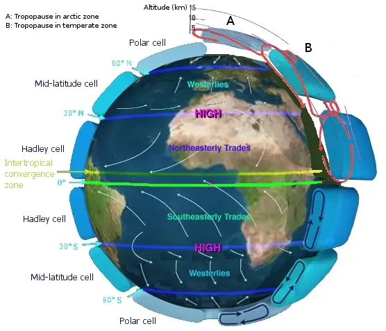
Jet stream

Jet streams are fast flowing, narrow air currents found in the atmosphere of some planets, including Earth.[1] The main jet streams are located near the altitude of the tropopause. The major jet streams on Earth are westerly winds (flowing west to east). Their paths typically have a meandering shape; jet streams may start, stop, split into two or more parts, combine into one stream, or flow in various directions including the opposite direction of most of the jet. The strongest jet streams are the polar jets, at around 7–12 km (23,000–39,000 ft) above sea level, and the higher and somewhat weaker subtropical jets at around 10–16 km (33,000–52,000 ft). The Northern Hemisphere and the Southern Hemisphere each have a polar jet and a subtropical jet. The northern hemisphere polar jet flows over the middle to northern latitudes of North America, Europe, andAsia and their intervening oceans, while the southern hemisphere polar jet mostly circles Antarctica all year round.

Jet streams are caused by a combination of a planet's rotation on its axis and atmospheric heating (by solar radiation and, on some planets other than Earth, internal heat). Jet streams form near boundaries of adjacent air masses with significant differences in temperature, such as the polar region and the warmer air towards the equator.[2]

Other jet streams also exist. During the Northern Hemisphere summer, easterly jets can form in tropical regions, typically in a region where dry air encounters more humid air at high altitudes. Low-level jets also are typical of various regions such as the central United States.

Meteorologists use the location of some of the jet streams as an aid in weather forecasting.

Earth_Global_Circulation.jpg


https://en.wikipedia.org/wiki/Jet_stream


Coriolis effect

In physics, the Coriolis effect is a deflection of moving objects when the motion is described relative to a rotating reference frame. In a reference frame with clockwise rotation, the deflection is to the left of the motion of the object; in one with counter-clockwise rotation, the deflection is to the right. Although recognized previously by others, the mathematical expression for the Coriolis force appeared in an 1835 paper by French scientistGaspard-Gustave Coriolis, in connection with the theory of water wheels. Early in the 20th century, the term Coriolis force began to be used in connection with meteorology.

Newton's laws of motion describe the motion of an object in a (non-accelerating) inertial frame of reference. When Newton's laws are transformed to a uniformly rotating frame of reference, the Coriolis and centrifugal forces appear. Both forces are proportional to the mass of the object. The Coriolis force is proportional to the rotation rate and the centrifugal force is proportional to its square. The Coriolis force acts in a direction perpendicular to the rotation axis and to the velocity of the body in the rotating frame and is proportional to the object's speed in the rotating frame. The centrifugal force acts outwards in the radial direction and is proportional to the distance of the body from the axis of the rotating frame. These additional forces are termed inertial forces, fictitious forces or pseudo forces.[1] They allow the application of Newton's laws to a rotating system. They are correction factors that do not exist in a non-accelerating or inertial reference frame.

A commonly encountered rotating reference frame is the Earth. The Coriolis effect is caused by the rotation of the Earth and the inertia of the mass experiencing the effect. Because the Earth completes only one rotation per day, the Coriolis force is quite small, and its effects generally become noticeable only for motions occurring over large distances and long periods of time, such as large-scale movement of air in the atmosphere or water in the ocean. Such motions are constrained by the surface of the earth, so only the horizontal component of the Coriolis force is generally important. This force causes moving objects on the surface of the Earth to be deflected to the right (with respect to the direction of travel) in the Northern Hemisphere and to the left in the Southern Hemisphere. The horizontal deflection effect is greater near the poles and smallest at the equator, since the rate of change in the diameter of the circles of latitude when travelling north or south, increases the closer the object is to the poles.[2] Rather than flowing directly from areas of high pressure to low pressure, as they would in a non-rotating system, winds and currents tend to flow to the right of this direction north of the equator and to the left of this direction south of it. This effect is responsible for the rotation of large cyclones (see Coriolis effects in meteorology). To explain this intuitively, consider how an object that moves northwards from the equator has a tendency to maintain its greater speed at the equator (rotating around towards the right as you look at the sphere of the Earth), where the "horizontal diameter" is larger, and therefore tends to move towards the right as it passed northwards where the "horizontal diameter" of the Earth (the rings of latitude) is smaller, and the speed of local objects around the central axis of the Earth is slower.

https://en.wikipedia.org/wiki/Coriolis_effect

Temperature differences give rise to pressure differences and the wind blows because of it. The earth's rotation causes a nonlinear directional path.
 
The bottom line is that this "global warming" is much less pronounced in the S. Hemisphere than in the N. Hemisphere.
 
Status
Not open for further replies.
Find a Real Estate Appraiser - Enter Zip Code

Copyright © 2000-, AppraisersForum.com, All Rights Reserved
AppraisersForum.com is proudly hosted by the folks at
AppraiserSites.com
Back
Top